Garmin inReach Explorer+

7.3
7.3 score
(Gearweare.net) score (7.3)/10

Our Gearweare.net score is based on 3 different factors: Editor's rating after in-depth testing. User ratings submitted on this page Overall score from the "reviewmeter" based on reviews across the web the weight of each factor is: 40% editor rating 15% user ratings 45% reviewmeter.
0
Editor rating: 7.5 / 10
User's rating: based on 0 user ratings
1 star
0%
2 star
0%
3 star
0%
4 star
0%
5 star
0%
Add your Rating
Garmin inReach Explorer+ Review Facts

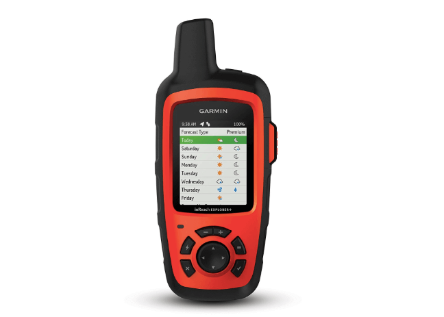
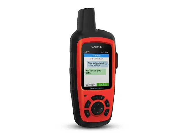
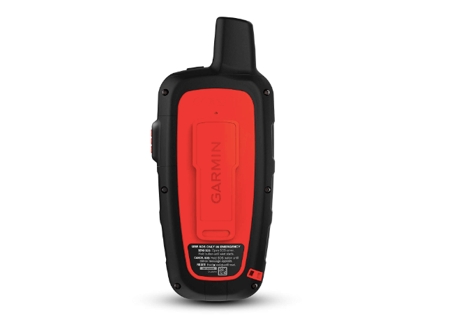
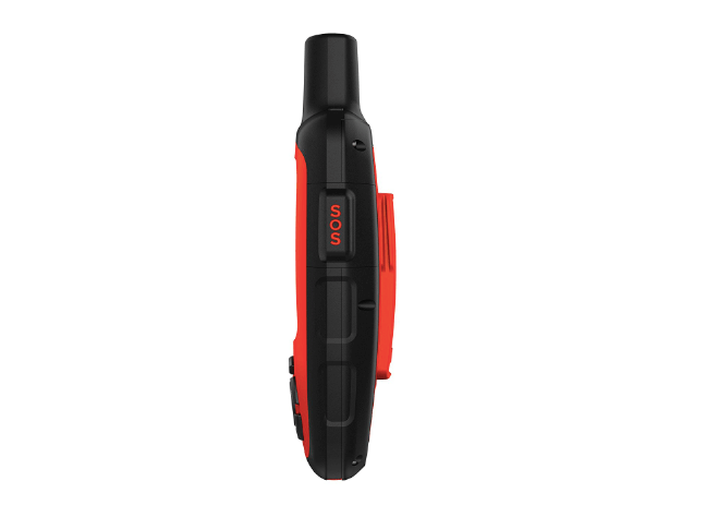
The Garmin Inreach Explorer+ handheld Satellite Communicator features 100% Iridium satellite global coverage wherever you are in the world. It has a USB interface that can be understood easily and is simple to use. The device works via subscription plans that can be set up simply through the Garmin website. Choose a monthly or yearly plan and only the features you want to include. Some qualities are already contained in the communicator for free, such as the topographic maps used for navigation. There are built-in sensors, so you can navigate better and track your current location and future destinations. Waypoints, planned routes, and breadcrumb trail are some of the navigation choices you can choose from with the Garmin device. There is a weather component to look at the forecast for where you are and where you are going. For emergencies, this communicator has a large button on the side marked SOS, which sends a direct signal to search and rescue for you. You can remain in contact with them until help arrives. Other mobile devices can be paired with the Inreach Explorer+ to share contacts and send messages anywhere in the world to any phone or email address. These other devices can also share your location and track the progress of your trip. Friends and family will no longer have to be in the dark about how you are doing and where you are thanks to the Inreach Explorer+. With the Earthmate app, MapShare portal, and DeLorme maps, there is much to explore with this outstanding device. Let us now take an in-depth look at all of the features in greater detail.

Editor's Pros & Cons
Pros
  • Includes Earthmate, Inreach, DeLorme, and MapShare apps and maps
  • Is durable, lightweight, and easy to use
  • Allows tracking and location sharing anywhere in the world
  • Has a simple, large, colorful interface
  • Can connect and communicate with other mobile devices
  • Location information and messages can be linked to social media accounts
Cons
  • The interface was trouble for some buyers in doing basic functions
  • This device does not have a camera as one of the features
See How
Reviews were analyzed here:
We read, analyze and sort reviews into positive & negative categories to give you the complete picture.
What are buyers saying?

We have spent 4 hours analyzing a total of 369 reviews.

These reviews are then categoried into "Positive" and "Negative" feedback.

Below you will read a summary of them:

Positive
  • For extra safety and peace of mind, many buyers recommend this device for all types of outdoor exploring.
  • The GPS is extremely helpful when navigating overgrown trails.
  • It's possible to link to smartphones via bluetooth.
  • The public portal makes data shareable.
  • Most buyers have had no issues using this device in less-traveled, more remote areas.
  • Satellite service ensures a way to contact people while out on the trails.
  • Mapping, messaging, and other features are customizable to suit your needs and preferences.
  • The S.O.S. function has helped many buyers in emergency situations.
  • If you can't rely on cell service where you are going, buyers recommend having this device.
  • There are reasonable data plans available.
  • Data plans can be changed or turned on and off based on usage.
  • You can check the weather on this device.
  • This device enables you to make last minute route changes and still keep loved ones informed from a distance.
  • Many reviewers agree that the high price is worth it for the safety this device provides.
  • The topo map helps you plan routes around difficult terrain.
  • It has a rugged, high quality construction.
  • For added convenience and safety, messages through the S.O.S. function and text messages include your location.
Negative
  • The screen is small.
  • Some buyers describe this device as clunky with an outdated interface.
  • It can take a bit of time to send and receive messages.
  • With tracking on continuously, the battery will drain significantly faster.
  • The unit is pricey and requires purchasing a subscription.
  • The GPS maps of Mexico are low resolution.
  • There are reports of firmware issues and problems connecting and syncing with Mac computers and older iPhone models.
  • Some reviewers note problems of delayed or failed navigation tracking.
  • A subscription is needed to use any functions.
  • Subscriptions must be purchased at activation.
  • There is a steep learning curve for some users who are new to Garmin products and software.
  • USB charging is not practical for long-term use.
  • It's only possible to use up to 500 waypoints in mapping at one time which becomes inconvenient for long hiking plans.
  • Issues using the Inreach website are reported by several buyers.
  • Some note that the GPS lacks some of the functions that other Garmin GPS devices have.
Reviewmeter
The Reviewmeter shows you an overall score that you can easily refer to. The highest rating is 10 (100% positive feedback)
Of the 369 reviews we found in total, 29% were negative, and 71% were positive.
7.1
1
5
10

Durability

The Garmin communicator is a durable device that can take much wear and tear but should be kept from unnecessary abuse in the outdoors. After all, for some people that are planning to go into deep remote areas, this incredible communicator will be the only means of contact until you get back to civilization. Take care of it well, and it should last a very long time. It can, however, withstand water exposure of as much as three feet or one meter for thirty minutes. It has a built-in battery for this reason and not replaceable batteries. The manufacturer planned on rough use in humid and wet conditions for this device, so the built-in battery was a better choice. It is durable, tough, and impact-resistant and IPX7 water-rated.

Flexibility

The whole idea of this ideal Garmin communicator is to be flexible and be able to communicate with others and the services you need anywhere and at any time. No matter where you are in the world, you should be able to contact family and friends and connect with the apps and programs that are in your subscription package. Physically, the Inreach Explorer is easy to use too. It includes easy push buttons on the front and a large screen for interaction and navigation. It is very user-friendly and fits well in the hand because of its ideal size and weight. This multi-tasking device weighs just eight ounces, so you can take it with you anywhere and tuck it away in backpacks and duffels easily. The large SOS button on the side is quick and simple to use for emergencies and a dependable feature that you can trust to work when you need it. Both physically and connection-wise, the Inreach Explorer is a flexible device that will allow you to go anywhere and remain connected.

Features

-Includes a USB interface that is simple and easy to understand
-Has built-in sensors for navigation and location tracking
-Features topographic maps that are preloaded for free
-Contains a weather component for getting forecasts
-The navigation includes waypoints, routes, and breadcrumb trail
-Can be paired with other mobile devices
-Includes trip and cloud storage planning
-Permits location and tracking sharing with other devices
-Has global two-way interactive SOS for emergencies
-Features 100% Iridium satellite global coverage anywhere anytime
-Allows messages and texts to other mobile devices
-Locations and messages can be linked to social media accounts

Use

This communicator comes with free access for the Garmin Explore site to plan trips routes, waypoints, and routes, make preset messages, update the firmware, create quick texts, manage the settings, download other TOPO maps, link accounts of social media, and store tracking data of the location destination. You can add in other maps from NOAA charts such as nautical charts and preprogram the route you want to take before you leave for the trip. It helps you stay on course during your trip. One popular topic about text messaging on this device was mentioned several times online. It seems that in order to have a text dialogue with someone, the initial message must first come from the Garmin communicator first to the cell phone you want to contact. Then the dialogue can go back and forth. The first text message cannot come from the cell phone because it will not connect. One way to get around this is to send a test text message to everyone you would want to communicate with on the trip to get a text dialogue started. Then they could contact you as they wish.

Advanced Features

The advanced features of this incredible communicator are made possible by the subscription you choose and the apps that you get. Get accurate up-to-date weather reports on this communicator from the weather service of InReach and Earthmate app.

It works in coordination with other mobile devices and the Earthmate app to access US NOAA charts, downloadable maps, and in-color images from aircraft. This Garmin device has preloaded TOPO DeLorme maps, a digital compass, accelerometer, and barometric altimeter courtesy of navigation sensors. The MapShare portal permits loved ones to follow your journey on their own mobile devices, and the MapShare page can be embedded on a website, blog, or social media. This outstanding communicator has 2 GB of memory and is a receiver that is high-sensitivity. You can pair it with an Android or Apple device for more convenience and capabilities such as aerial images, unlimited maps, and charts from US NOAA.

Connectivity

Connecting you to the world you leave behind in traveling to remote areas is the purpose of the Inreach Explorer+. You should not have to give up your link with others because there are no cell towers or services where you are going. Even with cruise ship travel and air flights, this device can be used to keep you on track and let others know where you are. The connection for the terrific Garmin device is provided by monthly or annual contracts for usage. The satellite subscriptions can be accessed by the Garmin websites. Just choose the type of plan and contract you want to depend on the various things you want to activate. You can use the features of the Inreach technology on a paired device such as an Android or Apple phone for better connectivity. The Garmin communicator can be synced to the contact list on the mobile phone to make contact easier and faster. Making the human or location connection is what this device is all about. It was made for the outdoor person who wants to travel farther and do more without worrying about friends and family with their unknown whereabouts. Now everyone you know can know exactly where you are as they track the progress of your journey and send you messages along the way. you will always feel connected even in the most remote places on earth.

Ease of Use

Once the Garmin communicator is programmed, it is very easy to use in the field. It features Iridium global satellite coverage that allows text messaging two-way from any place and even permits an SOS signal to a search and rescue center. You can keep in contact with search and rescue for emergencies and get confirmation of when they will arrive. Friends and family can know your location with this device no matter where you are, as you can exchange dialogue via text messages anywhere in the world with an email address or phone number. Monitor and track the progress of your journey with the GPS and get weather forecasts for your destination or current location. With the many pre-programmed maps, weather predictors, and location features, you will never be off-course or lost, especially when you pre-program your destination.

Power Source

The Garmin Inreach Explorer operates without a cell tower or phone service and works well in the backcountry and all over the globe. It can be used on land, in the air, or on the water. This wonderful communicator includes one required polymer lithium battery as the sole power source. Included is a special micro USB charging cable. Take care not to lose it says, one reviewer because not all USB cables work with this device. It can be recharged outdoors or away from electricity with solar packs and has a long life. This device operates on a built-in battery rather than replaceable ones for the reason that its main use will be outdoors. The manufacturers decided to use such a battery to permit is some resistance to the weather elements and to have a longer life. One buyer gave a few tips on how to increase the battery power when you will be away from a source of recharging for a long time. You should reduce the brightness of the screen, turn the tracking off or decrease it to just once a day, turn the internal log off, make the screen turns off after a minute of being on, turn the device off at night when you sleep, and let friends and family know a specific time to call or text. Doing these things will gain some extra time with the charge you have.

The Bottom Line

If you go traveling to remote areas a lot for recreation, work, or travel purposes, then this Garmin Inreach Explorer+ Handheld Satellite Communicator would be a wonderful device to have. When you go off to locations without any phone service or cell towers, you are disconnected from your friends and family and even the world. While this may be your intent in the first place, you can still remain connected via this incredible device for emergencies and peace of mind for the ones you love.

Not knowing where someone is can be troublesome, and this small communicator can solve that problem. It operates by a service plan that you set up yourself online through Garmin, where you choose the features you want on your communicator. It comes with several free things like some of the maps, but you will want the other services too. This great communicator can connect with other mobile devices for messaging as well as email. It can be used on land, in the air, or on the water, so if you are planning on taking a cruise or a flight somewhere, this might be a great thing to have with you. Before your trip, you can pre-program your itinerary with the maps and navigation elements. Following this via the internal GPS and compass will keep you on track so you never get lost. Even better is the fact that your friends and family can track your movements too on their devices. Besides the maps, you can access weather predictions for the current location and the areas you will be going with the Inreach Explorer+. You will soon see when you use this terrific device that you would be lost and disconnected without it. For the best communication in remote places all over the world, give the Garmin Inreach Explorer+ a try for your next adventure away from home.